
9623 Saint Charles Rock Road
Breckenridge Hills, Missouri 63114

CHAPTER TWO - The Trail West
![]()
|
The Trail West:
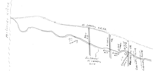
The original Saint Charles Road followed an Indian trail to the Village of the Missouris. According to Louis Houck's history, the road, which was granted by the Spanish King, who was proprietor of the Domain (what is now the Missouri area), was used mainly to accommodate people to whom he had made grants of land west of Saint Louis. The first information of a road connecting Saint Charles and Saint Louis was the old Spanish Road laid out in 1772 when Saint Charles was a wilderness. General Victor Collot's map of the Country of Illinois, dated 1796, shows the Saint Charles Road leading from the Saint Louis Stockade through the Saint Louis Common fields and Grand Prairie Common fields on the banks of the Missouri River opposite of Saint Charles. Two road spurs went to the north, the first connecting with what is now Florissant and the second with what is now Bridgeton. About 1817, the settlers using the road west were mostly from Kentucky and Tennessee. During October of that year, no less than 270 wagons and four-wheeled carriages, and 50 two-wheeled carriages and carts passed along the road, taking not less than 3,000 person into Saint Charles County. It was estimated that some 12,00 settlers preceded them at a rate of about 20 wagons a week for a period of nine or ten weeks. In front of the DeHart Mansion at Isolda Avenue and Saint Charles Rock Road, as it is known today, was a "12 Mile House". Food and drink were available to the travelers from Saint Louis to Saint Charles as well as water, food and rest for the horses. Saint Charles Road in 1819 was established as a post and stage road. If we would listen we might be able to hear the old wagons and horses traveling along either for pleasure, business or many, many times matters of State. It was not until August 9, 1834, that the court declared the road a public highway from the Catholic Grave Yard to the ferry on the Missouri River opposite of Saint Charles. The road proceeded next along what is now known as Franklin Avenue, pas the Saint Louis City limits which ended at Carr Square and continued along Easton Avenue past what is now Wellston, Missouri on what is now known as Saint Charles Rock Road in a continuous trail to the ferry on the Missouri River opposite Saint Charles. In the early 1830's, records mention Saint Charles Road passing through what is now Breckenridge Hills. "Beyond the Governor Miller place Saint Charles Road ... cross Cold Water Creek, when by the place of James Brackenridge."
Saint Charles Road did not cover the route it does today as it passes through Breckenridge Hills, but took a route that passed over what is now Burton Avenue and past the Brackenridge house which is now located at an odd angle at 3343 Edmundson Road. It also went on Foster and Benson Avenue and through what is now Saint Ann. It continued on past Fee Fee Cemetery to the Missouri River.
In 1837, the Road was incorporated and became a Turnpike. It was to be kept open at least eighty feet wide and twenty-four feet would be macadamized. The company would be permitted to erect three toll gates. The rates were not to exceed the following: For each man and horse 6 1/2 cents
In 1865 a petition was
filed with Saint Louis County Court indicating in that year the entire
road between Saint Louis and the Missouri River opposite Saint Charles
had been constructed of rock. After this improvement the highway was
termed The road as designated then ran form Saint Louis to Saint Charles by way of Elleardsville Post Office, Cote Brilliants Settlement, Rinkelville Post Office, Camp Marvin and Hartville. All of these post offices and settlements have passed into history and in their places have sprung up the communities of Wellston, Breckenridge Hills, Saint John's Station, Pattonville, and West Lake Park.
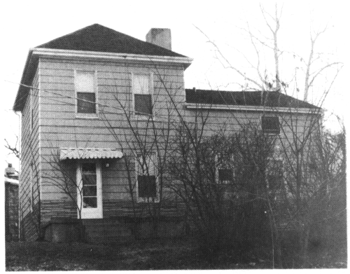
Another old landmark in
Breckenridge Hills is the DeHart Mansion. (The mansion, after years of
neglect, was torn down and removed, being replaced by the current
Hickory Trace Apartment complex.) The mansion pictured here- 
was a lovely example of a building of the 1800's. A point of interest is that the DeHart family had numerous farms beside the one in Breckenridge Hills. One of special interest owned by them was sold to the City of Saint Louis for the first land acquisition of the Lambert Airport. Under the Hayes Road Law, the Saint Charles Rock Road became the first concrete state highway in Saint Louis County and one of the first and longest stretches of state roads in Missouri Developed under the State Highway Department. Concreted from Wellston to Saint Charles, a distance of about twelve miles, at a cost of $600,000.00, the improvement was completed in 1921. At the turn of the century, trolley cars came into existence on the Rock Road. On January 17th, 1932, the Saint Charles Line west of Edmundson Road was discontinued. The tracks ran along the north side of the Rock Road. The western terminus loop was near Edmundson Road after 1933. From 1933 until December 28th, 1949, rush-hour service on the street car was available. Today the sound of the street car has become a pleasant memory of the past (replaced with a Metro Link line which has a station some five miles east of Breckenridge Hills, on Saint Charles Rock Road). Today the portion of Saint Charles Rock Road that passes through Breckenridge Hills is much wider than it was in the early 1800's. The road has been straightened out and widened. It no longer passes the Breckenridge house or winds its way out to Fee Fee Cemetery. People do no have to stop at toll gates or watch for horses, sheep or hogs. They don't have to watch for the street cars as they drive through the (city) at 35 miles-per-hour.
|
![]()
Onto CHAPTER THREE - The Black Community!
History | Police Department | Building Inspector | Street Department | City Clerk
© 2001 City of Breckenridge Hills
9623 Saint Charles Rock Road
Breckenridge Hills, Missouri 63114
314.427.6868